daniel.noreland@skogforsk.se
+46 (70) 911 87 67

The main objective of Northern Traffic Lights is to create a new knowledge network for testing and development of digital solutions for monitoring and predicting trafficability and maintenance needs for private gravel roads. The aim is to ensure more resilient supply for forestry and natural resources to support transition to a green and sustainable rural economy in a changing climate.
Lead partner in this EU-project is Natural Resources Institute Finland (Luke) with Kari Väätäinen as projectleader.
Luke will perform coordination and financial management for the project. The networking and dissemination leader in WP5 is Skogforsk. This forms a core-coordination partners for the project. Teams-workspace for internal communication, and documental information storage and change will be established and maintained by the core-coordination partners.
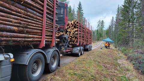
The importance of trafficable private gravel roads in the Aurora area is substantial. The transport volumes of northern forest industries are high and expected to increase. Moreover, timber trucks are now twice as heavy as they were when most of our forest roads were built, and many of the gravel roads become impassable during the freeze-thaw cycles and rainy seasons. With climate change the impassable time is expected to increase and roads will deteriorate faster.
Today, the information on gravel road trafficability is based on local knowledge from residents and operators, which is fragmented, imprecise and difficult to obtain and use. A new approach enabling real-time information on trafficability would enhance transport economy, make road maintenance more cost efficient and save limited sources of gravel material. New road information would help people in rural and remote areas with business activities like farming, forestry, tourism, green businesses, and public well-being.
The main objective of the project is to develop digital solutions for monitoring and predicting i) trafficability and ii) maintenance needs for private gravel roads. The aim is to ensure a more resilient supply for natural resources and improved accessibility of people and other business to support transition to sustainable rural economy. Project results are strongly based on the use of rapidly developed open data sources, increased utilization of vehicle data and digitalization opportunities to develop visual map-based decision support concepts for the road users, and other stakeholders.
Project includes five work packages:
Private gravel roads provide the primary access to natural resources in the Aurora area. Most of these roads were established during 1960-1990. As roads deteriorate over time, trafficability is reduced accordingly. Todays transport volumes for northern industries such as forestry are already high and are expected to increase. However, with climate change seasonal variation in trafficability is increasing with more frequent freeze-thaw cycles and extreme rainfall events. Lightly built gravel roads are often impassable during these periods. Climate change effects will be particularly strong in the Aurora region where cold winters have so far ensured high carrying capacity of gravel roads.
The transport of both private individuals and industrial raw materials relies on local trafficability information from residents and heavy-transport operators. This information is fragmented, imprecise and difficult to obtain and use. In order to adapt to the changing climate, new approaches to monitoring and forecasting trafficability are needed to improve decision-making for all stakeholders. Stakeholders include road owners, timber transport companies, road maintenance and renovation entrepreneurs, local citizens, workers within business, forestry and farming, as well as personnel within emergency/rescue services and fire departments.
This project is run by Nordic experts and researchers with most up-to-date knowledge and tools. We propose to develop a trafficability forecasting framework for private gravel roads in the Aurora area. In recent years, together with forestry stakeholders, we have developed and tested high-level digital solutions for handling and processing spatial data over large areas. Now we are ready to improve how we monitor and model road trafficability by combining data from lidar, satellite and sensor systems. A new online platform for gravel roads will improve transport, road maintenance and the use of limited gravel resources in the Aurora region.
The main target group consists of SMEs using and supplying gravel road information. SMEs providing forest operations and transport services need to know if a certain forest road is trafficable at a certain time in order to move forest machines and transport harvested logs. Such companies would prefer to see the trafficability information integrated in their existing logistics management systems, which brings work opportunities to IT companies. Companies providing road maintenance services would also benefit from up-to-date road condition information. These needs have been discussed with representatives for many years. The objective and scope of the project have been discussed with harvesting, transport, road maintenance and IT companies listed as stakeholders or associated partners in the attachment. All of them fully support the project. Furthermore, the project is supported by interest organisations representing harvesting and transport companies (e.g. Suomen Kuljetus ja Logistiikka SKAL ry and Koneyrittäjät ry).
Creative Optimization Sweden AB
Finnish Forest Center (FFC)
Finnish Meteorological Institute (FMI)
Linnéuniversitetet
LUKE
Luleå tekniska universitet
Skogforsk
Sveriges lantbruksuniversitet
University of Eastern Finland
University of Oulu