Planning forest routes for silvicultural activities using GIS based techniques
https://www.skogforsk.se/kunskap/kunskapsbanken/2011/planning-forest-routes-for-silvicultural-activities-using-gis-based-techniques/
In recent decades, exploitation of forest woods, specifically by application of operational machineries, has exerted severe pressure on basic elements of forests, such as soil and water.
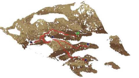
This study developed a GIS-based technique for planning main access routes for logging operations in harvesting sites in a manner to minimize environmental damages to soil and water. A model was created within the model builder environment of the ArcMap, version 10, using the existing tools in Spatial Analyst and 3D Analyst extensions of the ArcMap.
Nr 83-2011
Publicerad 2011-01-01 00:19
